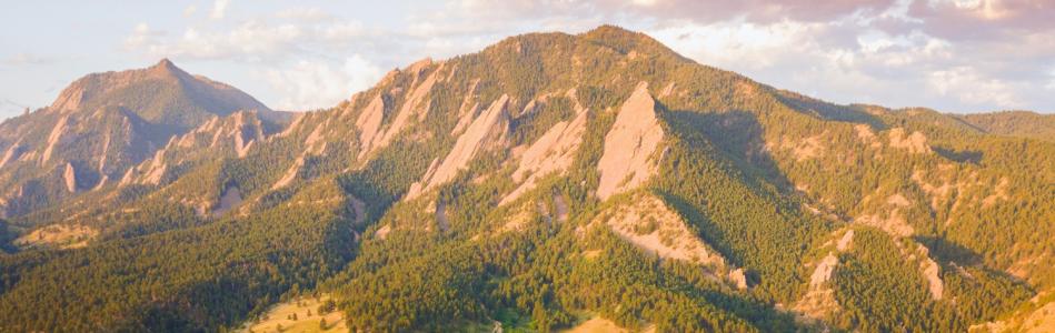
Close Menu
Group of four women with a dog hiking Chautauqua with the Flatirons in the winter

Chautauqua Hikes

There’s something of a magnetic pull toward Boulder’s Flatirons. When you get up close to them, you’ll see why. These massive sandstone slabs are almost unreal in their beauty, standing out in super-natural clarity against the blue Colorado sky.

The best way to really explore this iconic area is on the network of hiking trails that criss-cross the landscape in the area referred to generally as Chautauqua. But there's also a cute shop to buy mementos, Boulder's best porch and our vintage VW mobile visitor center. Read our Insider's Guide to learn more (including the history of its name).

Help protect Boulder's natural beauty by remembering these Leave No Trace principles, and before you go, check here for trail closures due to trail conditions.


Ride the Free Chautauqua Shuttle on Summer Weekends

The free weekend Park to Park Shuttle will get you there stress-free and avoid parking fees. Here's all the information on the free Park to Park hiker shuttle, which runs on weekends from Memorial Day to Labor Day. It is fully wheelchair accessible.

Accessibility Info

The City of Boulder's Open Space and Mountain Parks program has assembled an excellent set of resources for hikers using wheelchairs, walkers and scooters, including an incredibly thorough and helpful 40-page accessible trails guidebook (PDF) available for those seeking information about accessible hiking trails in Boulder. 

Chautauqua Hiking Trails

Try these hikes for up-close views of the Flatirons, panoramas of Boulder from above, wildlife sightings, wildflowers and more.

Chautauqua Trail Map

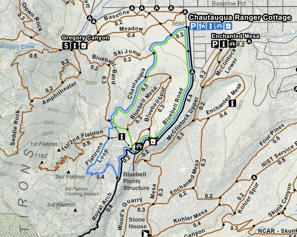
Click below to view the City of Boulder's trail map for the Chautauqua area.

Chautauqua Trail Map

Chautauqua Trail

Dogs allowed: Yes, leashed
Trail Map
Where to Park

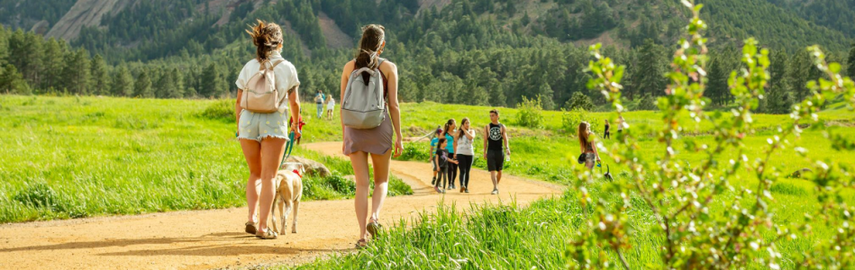
The Chautauqua Trail is where you’ll want to have your camera out for some classic Flatiron pics. This front-and-center route is like a church aisle leading to the altar of the Flatirons, flanked by tall grasses and sprinklings of wildflowers. You’ll likely join a scattered procession of hikers almost any day of the year. The trail hits a junction at the end of the Bluebird-Baird Trail, with a number of trail options from there.

Flatirons at sunrise with sweet peas - Tom Mangan

icon
Only in Boulder

In 1967, Boulder became the first city in the U.S. to tax itself for the acquisition, management, and maintenance of open space (or protected land). The beauty of this spot in front of the Flaitrons helped inspire this movement.

Woods Quarry Trail

Dogs allowed: Yes, leashed
Trail Map
Where to Park

Discover an old stone quarry where large sandstone slabs have been rearranged into an outdoor living room by a few creative folks. Bring a picnic to fully enjoy this unique spot. Start on Bluebell Road, then take the Mesa Trail to a fork, then go right on Woods Quarry. After enjoying the scenic viewpoint, head back down on the loop to pass by a mysterious, old stone cabin.

icon
Tree-Hugger Tip

When the sun warms Boulder’s ubiquitous ponderosa pines, their bark can give off wonderful aromas. Some think it smells like cinnamon, while others think it resembles ice cream or chocolate.

First and Second Flatiron Trail

Dogs allowed: Yes, leashed
Trail Map
Where to Park

The individual slabs of the Flatirons are numbered one through five starting with the largest (No. 1). The First and Second Flatiron Trail takes you right up to the two most prominent Flatirons (and, consequently, draws a steady stream of visitors most days). Start out on the Chautauqua Trail and then follow signs for “1st/2nd Flatiron.” You’ll end at the saddle between the First Flatiron and Sunset Rock.

Second and Third Flatiron Trail (Flatirons Loop)

Dogs allowed: Yes, leashed
Trail Map
Where to Park

This classic Boulder trail gets you up close to imposing views of the first and second Flatirons. You'll start through the Chautauqua Meadow, itself replete with breathtaking Flatirons views that are framed by fields of wildflowers in summer. The trail eventually crosses through a scree field before coming to the notch between the second and third Flatiron. Just after this point, be sure to stop to take lots of pics of Flatirons number three on the horizon. 


A post shared by Aaron (@aaron_traveling)

Bluebell Road

Dogs allowed: Yes, leashed
Trail Map
Where to Park

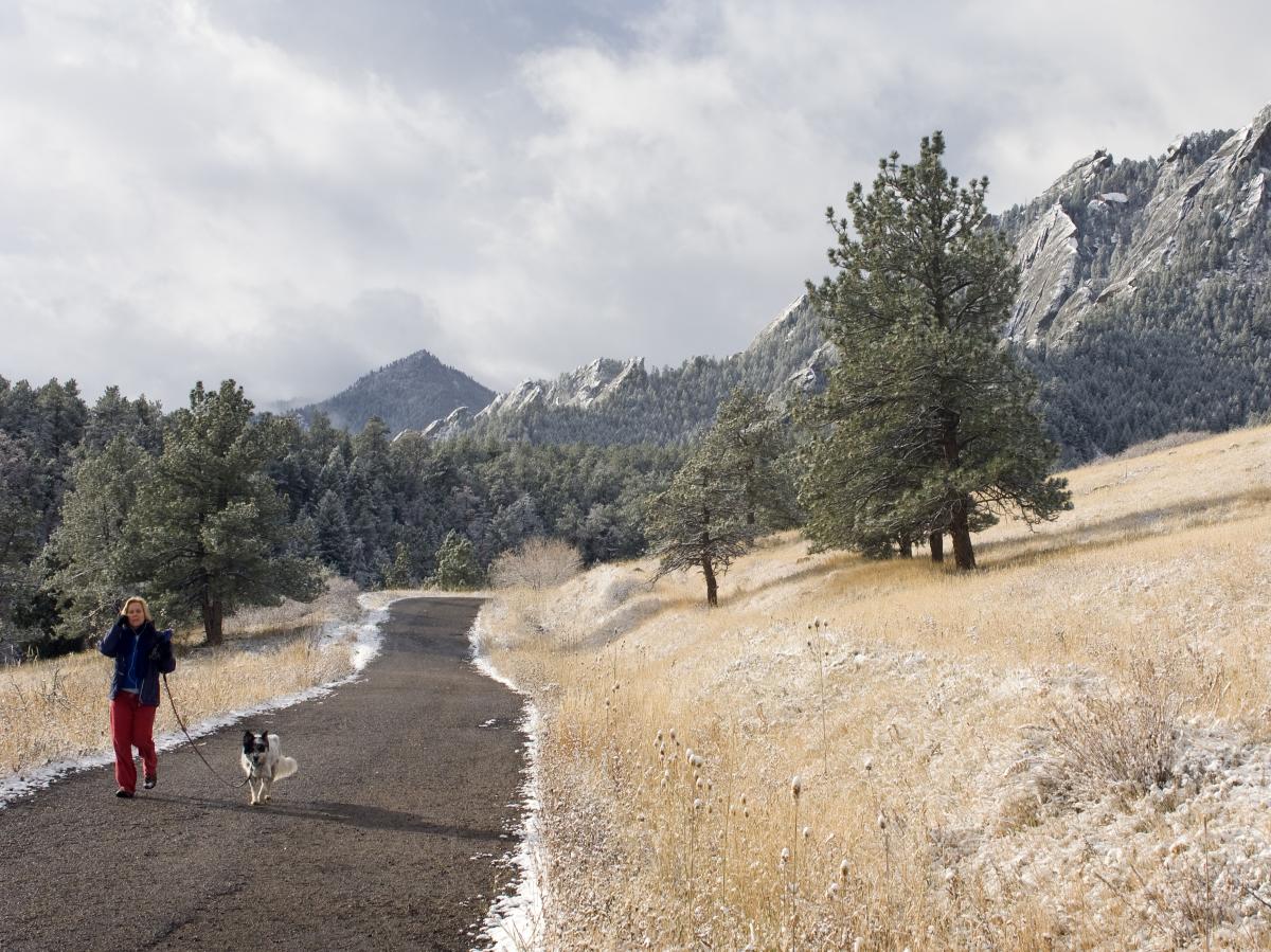
This access road provides nice, wide, even terrain up a moderate but steady incline. While it skirts the edge of the more mountainous areas, you’ll still get great views of the Flatirons. It’s where many of the popular trails in this area begin or end.

Person with their dog taking a winter hiking at Chautauqua

Bluebell Mesa Trail

Dogs allowed: Yes, leashed
Trail Map
Where to Park

The Bluebell Mesa Trail spurs off of the Chautauqua Trail, providing a lovely, easy-going (if brief) route lined with ponderosa pine.

Ski Jump Trail

Dogs allowed: Yes, leashed
Trail Map
Where to Park

This short jaunt connects the Chautauqua Trail to the Bluebell-Baird Trail and is a good spot to grab a picture of the Flatirons from a more northerly angle across the meadow.

Royal Arch Trail

Dogs allowed: Yes, leashed
Trail Map
Where to Park

This thigh-burner is well worth it for the reward at the end: a massive, sandstone arch that frames views of Boulder and beyond. It is the most popular trail in Boulder for a reason. You’ll start at the Chautauqua Trailhead, take Bluebell Road to the Bluebell Shelter, then follow signs for the Royal Arch Trail. The terrain is often stair-stepper-like, so be prepared to have some “are we there yet?” moments.

icon
Share Our Trails & Parks

Let nature's sounds abound. Many of us head out onto the trail system to find peace and quiet or to listen to the birds chirp and the leaves flutter in the breeze. If you're going to play music, don't assume everyone else wants to hear what you're listening to — kindly use headphones.
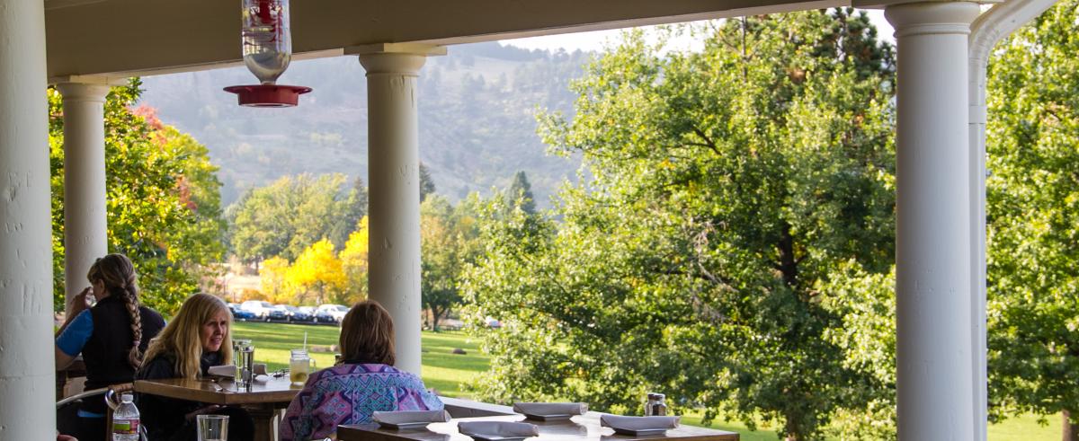
McClintock Trail (Lower & Upper)

Dogs allowed: No
Trail Map: Lower & Upper
Where to Park

The McClintock Trail starts at the picnic area just south of the Chautauqua Auditorium. Along the beginning of the trail, bright poppies bloom in the summertime. The route descends into a lush stream-side forest, then climbs gently and crosses the fire road at a stone bridge. The trail continues to climb along the edge of a shrub-filled gulley until it intersects with the Mesa Trail. 

Enchanted Mesa Trail

Dogs allowed: Yes, leashed, but please note dogs are prohibited on the Lower & Upper McClintock trails. Please see a map of dog regulations here.
Trail Map
Where to Park

Enchanted Mesa Trail also starts just south of the auditorium. Follow the gravel fire road through the metal gate and continue on across the stone bridge. The trail climbs gently to an overlook point with spectacular views of Boulder, then winds into a ponderosa pine forest until it connects to the Mesa Trail.

Gregory Canyon Trailhead

Dogs allowed: Yes, leashed
Trail Map
Where to Park

Also accessible from the Chautauqua Trailhead is a network of trails leaving from the nearby Gregory Canyon Trailhead. If you wish to explore this area, just walk along the Baseline Trail for about 0.7 miles, parallel to Baseline Road. Popular trails such as Gregory Canyon and Amphitheater to Saddle Rock depart from here. You can also connect back to the Chautauqua trail network from here via the Bluebell-Baird Trail.


Eats and Treats

The General Store carries delicious ice cream and hot chocolate if you feel like rewarding yourself after your hike. For a more substantial, farm-to-table meal, ask for a table at the historic Chautauqua Dining Hall, whose wraparound veranda is a perfect spot for a post-hike toast.

People dining on the outdoor patio at the Chautauqua Dining Hall